The Richmond River is more than a scenic backdrop to Ballina. It is the reason the town exists at all.
Flowing from the ranges near Kyogle and winding its way to the Pacific Ocean, the Richmond River has shaped settlement, culture, industry and daily life in the Northern Rivers for thousands of years. Today, it remains the heart of Ballina, linking past and present in a way few natural landmarks can.
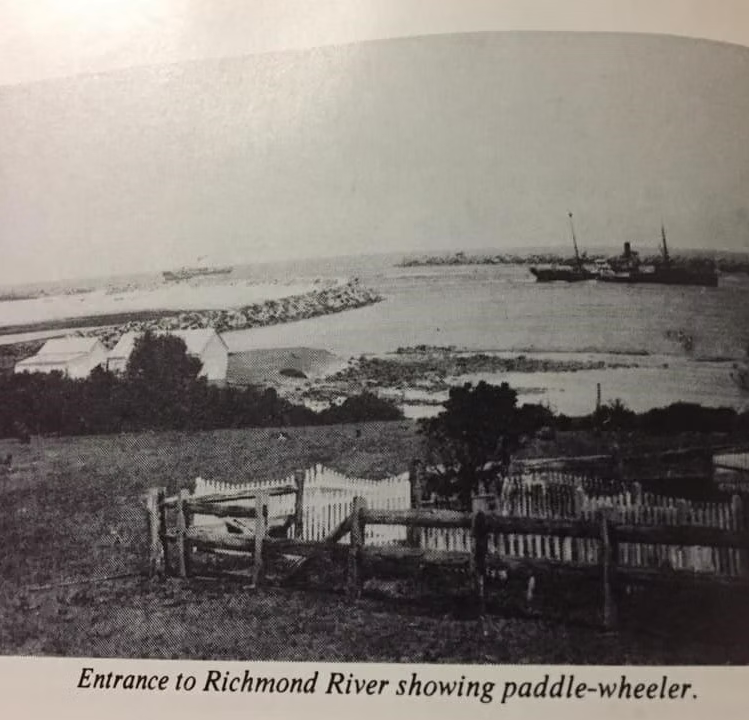
Image courtesy of Ben Dargie
Before Settlement: A Living Waterway
Long before Ballina became a coastal town, the Richmond River was, and remains, part of the traditional lands of the Bundjalung Nation, including the Nyangbal people in the Ballina area.
For countless generations, the river provided food, transport and connection. Fish, shellfish and other river resources supported community life. Canoes were used for travel along the waterway, and the river formed part of a broader cultural landscape tied deeply to Country.
The river was not simply a resource. It was and continues to be a living system with cultural and spiritual significance. Today, Traditional Custodians maintain strong connections to the river and surrounding lands, and local interpretive projects increasingly acknowledge and share these layered histories with visitors and residents alike.
Exploration and Early Industry
In 1828, Captain Henry John Rous explored the river and it was later named the Richmond River after the Duke of Richmond. The river quickly became significant to European settlers, particularly for its valuable red cedar.
Cedar cutters moved into the region in the mid 1800s, harvesting timber from the hinterland and floating logs downstream. The river acted as a natural highway, enabling transport long before proper roads were established. Timber, sugar cane and other agricultural goods were loaded onto boats and shipped out through the river mouth.
By the late nineteenth century, Ballina had grown into an important river port. Steamships regularly navigated the river, carrying goods and passengers between settlements. The river defined trade, employment and the economic future of the region.
Engineering the Entrance: The North Wall
One of the most significant developments in the river’s history was the construction of the North and South Walls at the river entrance.
The river bar at the mouth of the Richmond was historically dangerous, with shifting sandbanks and strong currents. Shipwrecks were not uncommon. To improve safety and navigation, extensive engineering works began in the late 1800s and continued into the early 1900s.
The rock walls stabilised the river entrance and reshaped the coastline. Today, the North Wall is one of Ballina’s most popular walking destinations, offering sweeping ocean views and regular dolphin sightings. What was once critical maritime infrastructure has become a scenic landmark enjoyed by locals and visitors alike.
Floods and Resilience
Like many rivers in Northern New South Wales, the Richmond has a long history of flooding. Major flood events have shaped town planning, infrastructure and community life.
Floods have tested Ballina and surrounding communities, but they have also highlighted the strength and resilience of the region. Over time, improved forecasting, flood mitigation strategies and infrastructure upgrades have helped reduce risk, though the river’s power remains a defining feature of the landscape.
Understanding the river’s flood history is part of understanding Ballina itself. The waterway is dynamic and ever changing, reminding residents that life here is closely tied to natural systems.
A Shift From Industry to Lifestyle
As road transport improved in the twentieth century, the commercial importance of river shipping gradually declined. Ballina evolved from a working river port into a coastal lifestyle destination.
Today, the Richmond River is more likely to host kayaks and fishing boats than steamships. Early morning paddleboarders glide across calm water. Families fish from the banks. Locals walk along the foreshore paths as the sun rises over the town.
The Martin Street Boat Harbour and riverfront precinct have become social hubs, surrounded by dining venues and accommodation. The river remains central to daily life, but in a different way than it was a century ago.
The River Today
The Richmond River continues to define Ballina’s identity.
It shapes the town’s layout, influences local events and provides a constant natural backdrop. From the Marine Rescue Tower to Pioneer Park, the foreshore blends history with modern interpretation.
Projects such as the Water Stories and Soundtrail experience invite locals and visitors to learn more about the cultural, historical and environmental layers that make up the river’s story. Through contemporary signage and geo located audio content, the river’s past is becoming more accessible and better understood.
Wildlife is also a defining feature. Dolphins are frequently seen near the river mouth, and birdlife thrives along the banks and wetlands. The river is both an ecological corridor and a recreational asset.
For visitors staying in Ballina, the river offers simple pleasures. A quiet coffee overlooking the water. An afternoon walk along the boardwalk. A sunset viewed from a balcony. It is an ever changing view that never feels the same twice.
Why the Richmond River Still Matters
The Richmond River is not just part of Ballina’s history. It is its present and its future.
It explains why the town developed where it did. It underpins tourism and lifestyle. It connects the hinterland to the sea. It continues to shape community identity.
For those exploring Ballina, understanding the river adds depth to the experience. It is more than a picturesque waterway. It is a story of cultural connection, exploration, industry, resilience and renewal.
Standing on the riverbank today, watching the tide shift and the light change across the water, it is easy to see why this place has drawn people for thousands of years. The river flows on, carrying its stories with it.